
የፎቶቮልታይክ ጂኦግራፊያዊ መረጃ ስርዓት

እባክዎ ከመቀጠልዎ በፊት የተወሰነ የመገለጫ መረጃ ያረጋግጡ
እርግጠኛ ነህ ግንኙነቱን ማቋረጥ ትፈልጋለህ?

የማረጋገጫ ኢሜይል አሁን ወደ እርስዎ ተልኳል፡-
እባክዎ መመዝገቢያዎን ለማረጋገጥ አገናኙን ጠቅ ያድርጉ።
Simulate solar production for your exact location with address precision using PVGIS
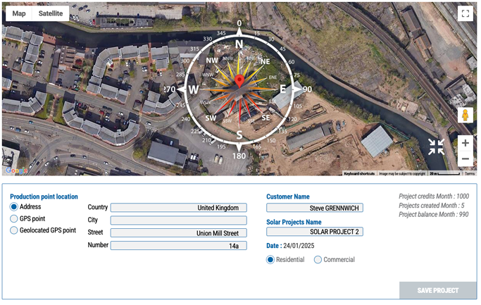
When planning a solar installation, having a realistic and personalized estimate is essential to ensure the profitability and efficiency of your project. With PVGIS, you can perform a detailed solar simulation based on your exact address, leveraging data specific to your location.
Accurate Data for a Solar Personalized Simulation
PVGIS stands out for its ability to integrate precise geographical and climatic parameters. By simply entering your address, the tool analyzes:
- Local sunlight exposure : The amount of solar energy available throughout the year.
- Altitude and topography : The impact of geographical features such as surrounding hills or plains.
- Climatic conditions : Temperatures, cloud cover, and seasonal variations.
- Potential shading : The influence of buildings, trees, or other nearby obstacles.
A Solar Realistic Estimate for Your Specific Needs
The solar simulation generated by PVGIS provides a clear and reliable forecast of your installation's energy production. It is tailored to your needs and includes:
- An annual estimate of the energy your panels can produce.
- The impact of local conditions on your installation's performance.
- Recommendations to optimize the orientation and tilt of your panels.
Plan and Optimize Your Solar Project
With the simulation results, you can:
- Assess the feasibility of your project based on your precise address.
- Compare different scenarios and configurations to maximize production.
- Anticipate potential savings on your energy bills.
Why Choose PVGIS?
- Precision : A simulation based on location-specific data.
- Accessibility : An intuitive interface for easy use.
- Reliability : Realistic forecasts based on updated databases.
With PVGIS, simulating solar production from your exact address has never been easier. Try this tool today to discover the solar potential of your location and optimize your solar project with reliable and personalized data.
20 BONNES RAISONS
D’UTILISER LE CALCULATEUR
SOLAIRE PVGIS24
- 1 የፀሐይ ፓነልን ትርፋማ እንዴት ማስላት እንደሚቻል PVGIS?
- 2 የፎቶግራፊክ ስርዓትዎን አፈፃፀም በትክክለኛው መንገድ ይተንትኑ
- 3 የፀሐይ መጫኛዎን አፈፃፀም በትክክል ይገመግማል
- 4 የፀሐይዎን ምርት ከፍተኛ-ትክክለኛ ካልኩሌተር ጋር ያመቻቹ
- 5 የፀሐይ ምርትዎን በትክክለኛ እና ቀለል ባለ መንገድ በመስመር ላይ ያሳውቁ
- 6 ከቅድመ ጥልቀት ጋር የፀሐይ ፓናል ውፅዓት ያስሉ
- 7 የፀሐይ ፓነሎችዎን አፈፃፀም ከ ጋር ያሳድጉ PVGIS
- 8 ለቤትዎ ስንት የፀሐይ ፓነሎች ይፈልጋሉ?
- 9 የነፃ የፀሐይ ብርሃን ካርታዎችን በመጠቀም የጣቢያዎን የጦርነት አቅም ይገምግሙ
- 10 የፎቶግራፊቲክ ፕሮጀክትዎን ትርፋማ (ፕሮፖዛል) ን ትርፋማ ከሚረዳ የገንዘብ ትንተና ጋር ያመቻቹ
- 11 የቤትዎን የፀሐይ ፍጥረታት ማምረት ከ ጋር ይገምቱ PVGIS
- 12 በአድራሻ ደረጃ ትክክለኛነት አካባቢ ያለውን የፀሐይ ፍጠርዎን ማምረት ያስመስሉ PVGIS
- 13 የፀሐይ ምርትዎን በፓነል ማተሚያ ትንታኔ ጋር ያሳድጉ
- 14 የፀሐይ ፕሮጀክቶችዎን አስተዳደር ያመላክታል PVGIS ሶፍትዌር
- 15 ለሶላር ፓነሎችዎ ምርጥ ማእዘን ይፈልጉ PVGIS
- 16 በአከባቢዎ የሚገኘውን የጂኦግራፊያዊ መረጃዎችን በመጠቀም የ SOLARALE አቅም መገምገም
- 17 ፕሮጀክቶችዎን ከ ጋር ያመቻቹ PVGIS ለፀሐይ መጫኛዎች መሣሪያ
- 18 የፎቶግራፍ ምትክዎን ትርፋማነት ከቅድመ ምሳሌ ጋር በመጠቀም ይገምግሙ PVGIS
- 19 የፕሮጀክትዎን አጠቃላይ ገጽታ ከላቁ የፎቶግራፊያዊ ካልኩሌተር ከ PVGIS