
PHOTOVOLTAIC GEOGRAPHICAL INFORMATION SYSTEM

Chonde Tsimikizirani Zina Za Mbiri Yanu musanapitilize
Mukutsimikiza kuti mukufuna kusiya kulumikizana?

Migwirizano ndi zokwaniritsa
Imelo yotsimikizira yatumizidwa kwa inu ku:
Chonde dinani ulalo kuti mutsimikizire kulembetsa kwanu.
Assess your location's solar potential with detailed geographic data
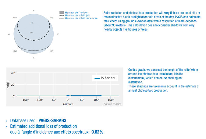
The success of a solar project depends on a precise evaluation of the site’s geographical and climatic characteristics. With PVGIS, you have access to detailed geographical data that refine calculations and optimize your photovoltaic installations.
Analysis of the Solar Potential of Your Photovoltaic Project
These carefully collected and regularly updated data provide a comprehensive view of the essential elements for analyzing solar potential:
- Relief : The topographical characteristics of your location, such as hills or plains, are integrated to measure their impact on sun exposure.
- Solar irradiation : PVGIS provides information on the amount of available solar energy, adapted to local specifics and seasonal variations.
- Climatic conditions : By considering temperatures, cloud cover, and weather changes, PVGIS offers a realistic simulation of energy performance.
By leveraging this data, PVGIS helps users understand how their immediate environment influences solar energy production. This information allows for the identification of the most promising locations and the design of installations perfectly suited to each site.
With PVGIS, evaluating the opportunities offered by solar energy becomes simple, precise, and accessible.
The integration of geographical data into calculations also makes it possible to simulate different scenarios and configurations. You can adjust parameters such as panel orientation and tilt to maximize efficiency while anticipating potential losses due to shading or other environmental constraints.
Whether you are a homeowner looking to equip your house, a professional solar installer, or an investor planning a large-scale project, PVGIS provides the necessary tools to fully exploit the solar potential of your location.
With PVGIS, evaluating the opportunities offered by solar energy becomes simple, precise, and accessible. Rely on reliable geographical data and optimize your photovoltaic project to achieve outstanding energy and financial performance.
20 BONNES RAISONS
D’UTILISER LE CALCULATEUR
SOLAIRE PVGIS24
- 1 Momwe mungawerengere zokolola za gulu la dzuwa ndi PVGIS?
- 2 Pendani magwiridwe antchito anu a Photovoltaic
- 3 Sinthani molondola ntchito yanu ya dzuwa
- 4 Khalani ndi zojambula zanu za dzuwa ndi cholembera chowongolera kwambiri
- 5 Yerekezerani zopanga zanu pa intaneti molondola komanso kuphweka
- 6 Fotokozerani zotulutsa zanu za dzuwa molondola
- 7 Kukulitsa magwiridwe antchito anu a dzuwa ndi PVGIS
- 8 Kodi mukufunikira mapanelo angati?
- 9 Sinthani mwayi wa tsamba lanu ndi mapu aulere a dzuwa
- 10 Konzani phindu la polojekiti yanu ndi kusanthula kwachuma
- 11 Yerekezerani kuti nyumba yanu yankazi PVGIS
- 12 Sinthani zopangidwa ndi komwe muli ndi adilesi yogwiritsa ntchito PVGIS
- 13 Onjezerani zojambula zanu zopanga dzuwa
- 14 Sinthani kasamalidwe ka anu PVGIS Mapulogalamu
- 15 Pezani ngodya yabwino kwambiri pa mapanelo anu a dzuwa ndi PVGIS
- 16 Sinthani mwayi wa malo anu okhala ndi deta yatsatanetsatane
- 17 Konzani ntchito zanu ndi PVGIS Chida cha Ou Adilesi
- 18 Sinthani phindu la kuyika kwanu pa chithunzi chanu ndi kuwongolera PVGIS
- 19 Fufuzani mbali iliyonse ya polojekiti yanu ndi Photovoltaic Caldicator kuchokera PVGIS